
How an unprecedented magma river surged beneath an Iceland town
A river of magma flowed underneath an Icelandic fishing village late last year at a rate never before recorded, scientists said Thursday, as the region suffered yet another dramatic eruption.
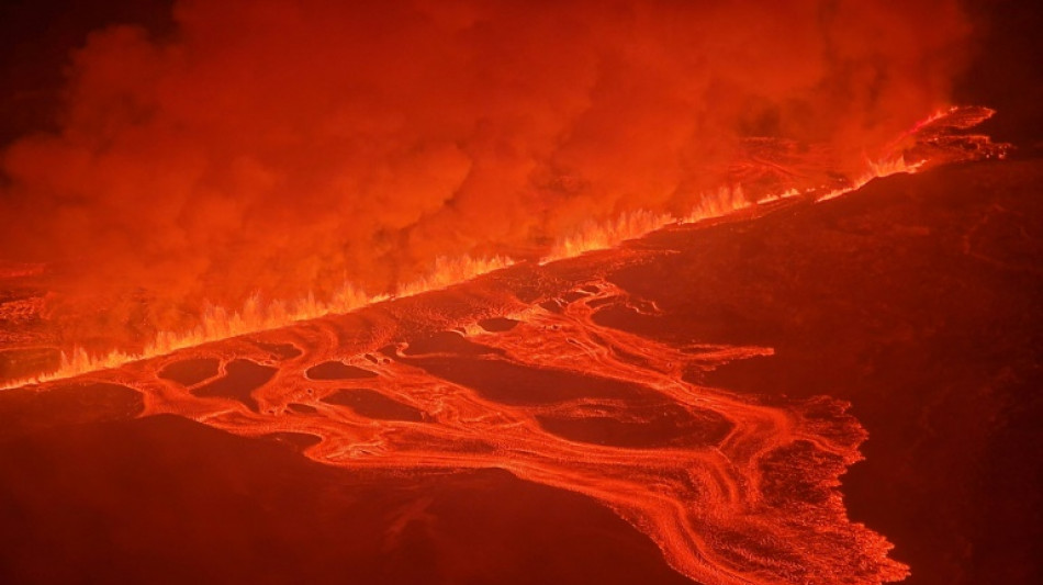
Authorities in Iceland declared a state of emergency on Thursday as lava burst a key water pipe during the third volcanic fissure to hit the western Reykjanes peninsula since December.
Before 2021, the peninsula had not seen an eruption in 800 years, suggesting that volcanic activity in the region has reawoken from its slumber.
After analysing how magma shot up from a reservoir deep underground through a long, thin "vertical sheet" kilometres below the village of Grindavik in November, researchers warn that this activity is showing no signs of slowing down.
That prediction seemed to be borne out by the latest fissure that split the Earth's surface near the now-evacuated village, which occurred just hours before the new study was published in the journal Science.
Lead study author Freysteinn Sigmundsson, a researcher at the University of Iceland's Nordic Volcanological Centre, told AFP that it was difficult to say how long this new era of eruptions would continue.
But he estimated there were still months of uncertainty ahead for the threatened region.
- A mighty molten river -
Over six hours on November 10, the surging magma created a so-called dyke underground that is 15 kilometres (nine miles) long and four kilometres (2.5 miles) high but only a few metres wide, the study said.
Before Thursday's eruption, 6.5 million cubic metres of magma had accumulated below the region encompassing Grindavik, according to the Icelandic Meteorological Office.
The magma had flowed at 7,400 cubic metres per second, "a scale we have not measured before" in Iceland or elsewhere, Sigmundsson said.
For comparison, the average flow of the Seine river in Paris is just 560 cubic metres a second. The magma flow was closer to those of larger rivers such as the Danube or Yukon.
The magma flow in November was also 100 times greater than those seen before the recent eruptions on the peninsula from 2021 to 2023, Sigmundsson said.
"The activity is speeding up," he said.
The November magma flow precipitated more serious eruptions in December, last month and again on Thursday.
Increasing underground pressure has also led to hundreds of earthquakes and pushed the ground upwards a few millimetres every day, creating huge cracks in the ground and damaging infrastructure in and around Grindavik.
The hidden crevasses that have riddled the town likely pose more danger than lava, Sigmundsson said, pointing to one discovered in the middle of a sports pitch earlier this week.
- More magma to come -
The village, as well as the nearby Svartsengi power plant and the famed Blue Lagoon geothermal spa, have been repeatedly evacuated because of the eruption threats.
The long-term viability of parts of the region sitting on such volatile ground has become a matter of debate.
Sigmundsson emphasised that such decisions were up to the authorities, but said this was definitely "a period of uncertainty for the town of Grindavik".
"We need to be prepared for a lot more magma to come to the surface," he said.
The researchers used seismic measurements and satellite data to model what was driving the magma flow.
Iceland sits on the Mid-Atlantic Ridge, a crack in the ocean floor separating the Eurasian and North American tectonic plates.
As these plates have slowly moved apart over the last eight centuries, "tectonic stress" built up that was a key driving force for magma to surge through the underground geological crack, Sigmundsson said.
The researchers hope their analysis could inform efforts to understand what causes eruptions in other areas of the world.
B.Vidal--ESF


